Taxonomy upgrade extras
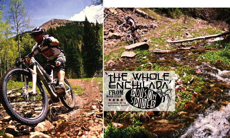
Moab, Utah
Words by Poison Spider
Photos by Nicholas Badovinac
From riding the Porcupine Loop on rigid bikes over fifteen years ago, to what mountain biking has become today, Moab has become the Mecca to which most of us must make a pilgrimage at some point. Like many who have made the trek, you may fail to resist its lure, and find yourself still there, floating in a state of abstract, near-hallucinogenic bliss permanently. I should know, it happened to me.
Moab calls out to thousands of riders every year to come and visit its vast network of singletrack trails speckled with the grippiest, yet least forgiving red rock on the planet. But one trail’s siren song is beyond irresistible, wailing through the nearby canyons, echoing off tall rock spires until she finds her next gullible prey. ‘The Whole Enchilada’ is a combination of trails linked together to create a 35-mile, 7000-foot test of your face’s ability to hold a grin. From 11,000 feet at the top of the La Sal Mountains, the starting point offers spectacular views into Colorado from talus fields and open meadows above the tree line. Turn 180 degrees and look at the Utah red rock desert below as you descend into the pines on your way to Burro Pass. Rocky and steep, Burro winds through trees, gaps streams, and throws roots at you like batting practice. Seemingly before you’ve had a chance to think, you will wonder where the hell the last 2,000 feet of elevation went. You’re under her spell now.
A quick pedal past Warner Lake and on to Wilcox Flat brings you to the next leg of your voyage, the Hazard County Trail. Once an unauthorized trail now turned legit, Hazard County is a twisty course through oak scrub brush and aspens. From the top, you get another taste of the grand scope of the area from the Abajo Mountains and Castle Valley, to views into Canyonlands and Arches National Parks. This trail will keep you on your toes with quick, bermed turns interspersed with rocky sections that beg for merely the lightest touch on your brakes.
Crossing the La Sal Mountain Loop Road brings you to a screaming fast section of the Kokopelli Trail, a double track with a burnt-in line that hops back and forth from one side to the other. Use caution as the speed and quick line changes can send you careening into a rut or a rock field. Kokopelli then slingshots you into the Upper Porcupine Singletrack trail. Yet another previously unauthorized route now on the up-and-up, UPS veers off of Kokopelli towards the vertigo-inducing rim overlooking Castle Valley. Pedal and pump down this singletrack along the rim and notice the change from mountain dirt to high desert sandstone. UPS sprints into LPS (Lower Porcupine Singletrack—also once authorized—notice a trend?), a ridiculously fun trail that will keep you under the siren’s thumb as you cruise down the rim. Don’t forget to sit for a minute and dangle your feet off of the massive cliff edge you were just riding along and wonder whether that high-pitched sound you hear is a hawk, or possibly something else… Take a few photos of the giant slickrock hoodoos scattered about the valley below you, and have a snack before you commence shredding again.
Half way through LPS, your face will get a slight reprieve from hard grinning; it will turn to a jaw-agape look of awe and confusion when you reach the ‘Notch.’ Yes, the trail really goes where you see it heading: straight down into a steep, technical abyss that only a handful of people actually rides. After that is a steep slide through some switchbacks until you hit the bottom and climb back up the other side to the rim once more. The last little section of LPS is one of my favorites, with great flow all the way into the original Porcupine Rim. Here the trail opens up into a large slickrock gathering point where there are two options. If you’re spent or need to bail for time, turn hard left and descend the 3.5 miles down to Sand Flats Road and coast into town. This section is ledgy and super fast, but be careful again to pick a good line, as there are many spots that will spit you out onto the rocks like a wad of gum. If you plan to continue down Porcupine Rim to the Colorado River, follow the trail straight ahead. The next few miles flatten out and have a few short climbs; then, the terrain will become noticeably more technical.
Pointing it back downhill, the trail consists of long rock fields where a good line and lots of energy are key. Powering hard through this gradually descending trail will send you skipping across the rocks, over ledges, past your buddies (haha!). Keep your eyes peeled for alternate lines here and there with fun bonus drops and great technical features. Now you are in full-on Moab red rock! Eventually, you will reach a rope fence and the trail narrows down to the final section known as the Porcupine Singletrack and Jackass Canyon. Time to put the rest of your pads on, clean your glasses, and call your Mom. The temptress has led you straight into the maelstrom. Here she shoots you right out to the cliff edge and starts bucking you off ledges and throwing you through swooping dips and humps at full speed. A relentless string of tech-gnar brings you to the coup de grace known as Jackass Canyon, where exposure mingles with drops, corners, and tech moves worthy of a trials rider. One misplaced dab on the downhill side could find you falling fast into the Siren’s clutches. Survive the canyon, and you’re out the other side. Cruise the last section down to the Colorado River, drop your bike, kiss the ground, call your Mom again, and crack a well-deserved beer as you watch a trio of birds circle overhead, their cries piercing the desert silence one last time before drifting off into the distance.