Taxonomy upgrade extras
Taos, New Mexico
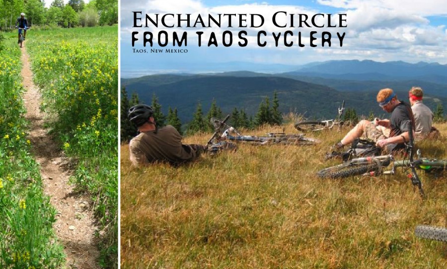
Words and Photos by Doug Pickett
Moab, Sedona, Fruita… These are the well-known giants of the Southwest when it comes to biking. For those looking to buck the crowds and venture a bit further a field, Taos is a hidden treasure with a huge payoff. Luckily placed along the Enchanted Circle road route and the South Boundary Trail head, Taos aims to please all types of riders. The best advice when coming to Taos is bring your teddy bear, eat your Wheaties, and if you’re not the praying type, now’s the time to start.
Granted, most people associate riding in the Southwest with sticky singletrack made to order for mountain biking. But Taos boasts long loops and big climbs burly enough to satisfy the heavy hitters when it comes to pavement. Of course, Taos has good back roads and a climb to the Taos Ski Valley that’s more scenic than difficult. But to be honest, most rides within city limits are best suited to recovery and plain old site seeing. Not that there’s anything wrong with this kind of riding but who can’t do that at home? Try a little harder and a cyclist in shape can go home with something to talk about.
The Enchanted Circle is the most popular distance road ride in the area. Eighty-five miles and two passes—the higher one, Bobcat tops out at 9,800 feet—make this loop a challenge for any serious rider. Those will some extra gas in their tank go out to Black Lake through Angel Fire and back over the Gorge Bridge near Taos and back to make it an even century. The annual tour of this route, starting in Red River, brings in over 500 cyclists a year. Finish in five hours or less and you can pat yourself on the back.
Even more challenging and scenic than the Enchanted Circle is the Mora Loop. This ride is mostly done counter clockwise, leaving Taos and going south along highway 518. Follow the road up and over U.S. Hill and on through Sipapu to Holeman Hill. Tighten your chinstrap and check your quick release skewers, because the descent into Mora from here is long and super fast. Once in Mora, head north to Guadalupita along highway 434. This is classic rural New Mexico countryside. As the road narrows riders will pass along forest adjacent to ranch land. The occasional dilapidated trailer home is complete with a satellite dish. The Christmas tree farm on one side of the road gives way to the barbed fenced pasture on the other side. As the road winds through this narrow canyon there’s hardly a section of straightaway, making you stretch to see what’s around each successive corner.
It starts getting hilly around Coyote Creek State Park, where things veer as close to mountain biking as it gets on paved road. Then, the forest moves in as the road hugs Coyote Creek; enjoy the scenery because you’re about to get slapped in the face with three steep pitches. The last one is the longest and hopefully you’re still upright to enjoy the Wheeler Peak Wilderness unfold before your eyes. Now you know why you came on this ride. The dense forest that surrounded you now opens up to a huge mountain vista. Your eyes will follow a small mountain lake in a meadow fed from the mountainside to a ridgeline that goes from one peak to another all the way to Wheeler, New Mexico’s highest. Hold on into Angel Fire, take a break, and finish with a steep two-mile climb to Palo Flechado Pass. The last fifteen miles down into Taos complete the 107-mile loop.
If that still doesn’t sate your hunger for high-altitude suffering, there’s always the New Mexico Death Ride. To date only two riders have knowingly completed this 215-mile monster, which starts and ends in Taos. Head north for a 35-mile warm up to Tres Piedras. Continue west along Highway 64 into the Brazos. This mountainous, scenic terrain is claimed by some to be the best road riding in the area. Once you pass the Brazos Cliff scenic overlook, descend into Tierra Amarilla. Turn north and finish your first hundred at Chama. Relax and have a burrito; the hard part is still ahead.
The climbing starts shortly out of Chama and gets harder every minute. The scenery gets superb just after the “Welcome to Colorado” sign; something not lost on us New Mexicans. It’s almost as if the border was drawn based on where the best scenery was—not some specific latitude or longitude designation—and New Mexico got the short end of the stick. Cumbres and Mongas Pass are both above 10,000 feet and the views are overwhelming. Once on top, you enter the Cruces Basin. This is a wilderness area that unfolds through meadows and forest like ruffled sheets. Short descents followed by short climbs at elevation lead to Mongas Pass. The descent off Mongas is as fast as your courage will let you go. The twisting winding road is perfect for carving your bike through high-speed turns. Hopefully there are no cars in the way to slow you down. Take a little time to look around at the jutting mountainsides that lead to Platoro. The road along the Conejos River undulates along the wide ribbon of water, leading you into a fast section into Antonito for a boost of confidence around mile 140. Between Antonito and Tres Piedras lies San Antonio Mountain, an extinct volcano that by some miracle of nature moves further away the closer you get to it. The reason you’re only going 12 mph is because of the constant low-grade climb up to, then around, San Antonio. Head down, dig in, you’re still not done yet.
The descent around this obstacle is short lived as you approach Tres Piedras to complete the loop. If your brain is still getting enough oxygen, you’ll vaguely recall passing through here sometime earlier this morning; now it’s sometime late in the afternoon and the finish into Taos is a welcome cool down. If you’re still turning the pedals, you hit the 200-mile mark around the Rio Grande gorge bridge. Everything from here on out is gravy. It may be euphoria, accomplishing a grand achievement, or just plain stupid, but finishing this ride is unlike any other.
Now for the mountain biking in Taos. This is why most cyclists come here in the first place. Taos is home to New Mexico’s most scenic and challenging off-road terrain, with trails accessible just outside town limits. Generally, the rides along the Rio Grande gorge, like The Rift Trail (formerly Taos Valley Overlook), the West Rim Trail, and Horse Thief Trail are appropriate for beginner to intermediate riders. No sustained climbs, and a lot of twisty and winding trails in and out of the trees. The views into the 600-foot gorge are unique to this area. The walls are steep and jagged with a narrow ribbon of river below. Be careful, as at least one person has fallen to their death while looking over the side and suffering vertigo. If you’re lucky you may see some of the eagles that nest in the walls here. Bring tubes and a patch kit because cactus await any rider who veers off trail.
The rides near town get a little more complicated, like the Talpa Traverse and Devisadero Loop. The Talpa Traverse is an unofficial gem located along the foothills just south of town. The constantly shifting terrain makes it a great skills builder, just watch for hikers and horses. Devisadero gives technical junkies all they can handle in a five-mile run. Steep rocky steps, 180-degree switchbacks, and tricky descents all help hone the skills of the locals who rip this trail on a weekly basis. Finish this one in 45 minutes or less and you can consider yourself among the elite.
The new kid on the block is Northside at Taos Ski Valley. The resort is privately owned land, so it’s “pay to play” and worth every penny. Start at the Ski Valley parking lot (9,200 feet), and climb to just over 12,000 in less than seven miles. Your pain will be sharp, but quickly soothed by the scenery. Can’t afford Switzerland this year? This is the next best thing. The views of Cachina Peak around the Wheeler Peak basin and into Colorado on the other side are unmatched in New Mexico. The payoff is the descent on signed singletrack with a mix of old mining road. The annual Frazer Mountain Madness hill climb and cross-country event bring insane climbing freaks to this one of a kind terrain every year.
Finally, the Camino Real ranger district of the Carson Forest is loaded with old abandoned forest roads that offer up over five hundred miles of interconnected loops and riding options. They’ve been closed officially to motor vehicles for years, but most of the trails are maintained by the occasional motorcycle or four-wheeler. While you could go out and ride for days, three routes are particularly worth the effort.
The Woodpile Trail is a hard to find jewel that starts out of Amole Canyon, near U.S. Hill. This particular part of the forest seems to be a little lusher and thickly vegetated than the rest. A combination of singletrack and forest road takes riders out to Gallegos Park, arguably one of the most scenic spots in the entire woods. A large rolling meadow leads down off the ridgeline, bordered by Aspen trees. If you’re here in the fall the trees are bright yellow. Looking south, you’ll have prime viewing of the Truchas Peaks, once thought to be the highest in New Mexico. Plan a break here to take in this spectacular view. A short traverse brings you back on some of the most splendid high-speed trail through tall grass and aspen forest. The only problem with this ride is that almost two hours of climbing yield only thirty minutes of descending.
Next up is Cerro Vista, the king of mountain bike rides in the Taos area. It’s forty miles in its shortest version, with 60 and 70-mile loops at the ready. Start at a humble 7,000 feet and climb to a leg and lung-busting 11,939. This is an all-day affair with all the food and liquid you can carry, and a water filter isn’t a bad idea either. The views from the top will make you feel like you’re on top of the world. Wheeler Peak in the distance is just about the only one higher. Look down upon South Boundary at a seemingly lowland 10,000 feet. You can see the contours that all Taos area trails traverse, a real-world map of all the favorite rides from beginning to end. To the south and east, the Rockies end and the plains begin. On the descent, you have the opportunity to hit personal speed records along steep forest roads, where long sections above thirty-five to forty miles an hour are not unheard of. Endurance experts only need apply.
Finally, there’s South Boundary Trail, a one of a kind in New Mexico. Visitors come from all over the country to ride this trail. At just over 20 miles, riders are gifted with scenic views as the trail traverses a ridgeline. The trail starts from high elevation old growth forest, winds through various aspen groves, and ends in desert pinion. Mostly singletrack with some forest road, this is what mountain biking is all about. Depending on how you confront this trail, there’s some to a whole lotta climbing. This is followed by a section of trail named “Heaven on Earth”—a fast, off-camber section of trail through a long aspen grove. In the fall golden leaves cover this section of trail, when locals designate it the “yellow brick road.” A tricky traverse through Garcia Park to Paradise Park leads you to a singletrack descent with a steep, technical finish that will eat you alive if you didn’t save some for the finish. This ride is so good that people will pay to be driven to the trailhead.
Taos clearly has enough cycling to satisfy any rider with an adventurous spirit. This is a relatively secluded area and it’s reflected in the riding. Road rides along mountain streams in canyons are plentiful; scenic mountain bike rides on long stretches of single track are the norm. Afterwards, enjoy a home brew and some green chile stew or a burrito at Eske’s pub while swapping ride stories with the locals. We are a civilized crew, if a little rough around the edges.